
Fairburn Estate
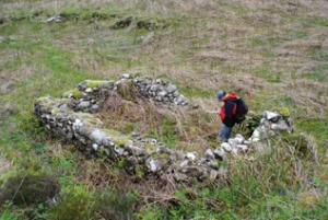
An archaeological desk-based assessment and walkover surveys were carried out on behalf of Treeline Forestry Limited and the Fairburn Estate in advance of proposed woodland creation schemes focused on the Allt na Fainich glen, Glen Orrin, and Gleann Goibhre on the Fairburn Estate, near Muir of Ord, Highland Region. The survey areas totalled over 1500 ha of upland landscape.
The walkover surveys recorded a total of 104 archaeological sites, some of these comprising groups of structures and archaeological features, such as shieling settlements, farmsteads and a significant number of prehistoric hut circles and stone clearance cairns, providing additional detail to the archaeological record. The recorded sites included a complex range of structures relating to prehistoric settlement, along with post-medieval farmsteads and their associated infrastructure, and a wide range of structures relating to transhumance activities in the landscape. These included shieling settlements, stone-built storage cells, a sheepfold, stock enclosures and twinning pens.
Many of the structures recorded during this survey are focused on Gleann Goibhre. In particular, the prehistoric settlement recorded at Cul Beag is extensive, with no sites in the surrounding landscape to compare on this scale. Therefore, the prehistoric hut circles, burnt mounds and associated field systems identified and recorded in Gleann Goibhre form an extensive and important group of monuments relating to upland Bronze Age settlement.
Overall, the archaeological sites recorded through the desk-based assessment and walkover surveys provided evidence for varied settlement and use of these upland landscapes throughout the prehistoric and historic periods; the later periods of use relating to the long-term settlement and more transient transhumance activities associated with the use of summer pastures and the management of cattle and sheep, and for the possible droving of livestock between different communities and to seasonal markets. The most recent use of these landscapes relates to their development as sporting estates, followed by the creation of facilities associated with renewable energy including hydro-electric generating systems and wind farms.


Fessenden Wireless Radio Station
West Coast Archaeological Services was commissioned by MOWI (Marine Harvest Scotland Ltd), Cowal Design Consultants and CP Architects to provide archaeological input with regard to a new fish hatchery complex at Lossit Point, Machrihanish, on the Kintyre Peninsula. The archaeological input had been requested due to the development being situated in a landscape with high archaeological potential. In particular, the construction of the fish hatchery would impact on the site of the Wireless Radio Station at Lossit Point, which was constructed between 1905 and 1906. The station, along with a similar facility built at Brant Rock, Massachusetts, in the United States, took part in the first wireless communication transmissions across the Atlantic. The work was the brainchild of Reginald Aubrey Fessenden, who has been named ‘The Father of Radio Broadcasting’.
What remains at the site today is a unique record, the sister station at Brant Rock having already been dismantled and destroyed in the face of new developments. The visible remains of the wireless station generally comprise concrete structures relating to various elements of its original construction, including the main engine house, telecommunications room, the base of the main mast/antenna, and concrete anchor blocks used to stay the antenna. Archaeological input at the site has included a walkover survey and detailed recording of the surviving structures, evaluation of the structures using targeted excavation, and an archaeological watching brief during site clearance works. This input has also been supported by a detailed desk-based assessment including targeted research on the Fessenden Archive held in the North Carolina State Archive.
Rosemarkie Caves Project
The Rosemarkie Caves Project has investigated the archaeology of 19 caves on the southeast side of the Black Isle, near Inverness, in Highland region. The project is run by a team of voluntary professional and amateur archaeologists and the results of the excavations and preliminary analysis of finds and materials have provided significant information about activity taking place inside the caves during the 1st millennium AD (although evidence for Iron Age activity during the closing stages of the 1st century BC has also been recovered from several of the sites.
Open area excavations have allowed the project to investigate in some detail the use of the available space within the caves and to interpret the activities that were taking place during the different phases of use. Initial interpretations suggest that metalworking was one of the earliest activities to take place in the caves, dating to the Early Medieval period. The use of the caves for craft activities and basic subsistence is also evident from the wide range of materials recovered relating to post-Medieval occupation. Other major discoveries relating to the use of the caves during the Early Medieval and Post-Medieval periods is the structural evidence defining the modification of the caves and the division of space.
A significant number of hearths and spot-fires relating to the use of the caves have been found relating to all periods of occupation, along with stone dividing walls, cobbled surfaces, and possible sleeping areas – the latter indicated by layers of decayed bracken and small branch wood. Below the post-medieval deposits in the caves, the archaeological sequences were quite different in character, suggesting that intermittent occupation was continuous, extending back through the Medieval and Early Medieval periods.
A c.5th-7th century male inhumation burial was found in a dark alcove below a post-medieval cobbled floor and midden deposits in one of the Learnie group of caves, the burial comprising the well-preserved remains of a young male who had suffered severe, multiple traumas to the head. The individual had been placed in an unmarked grave with stones weighting down the limbs and with butchered animal bone placed over the location of the head. The animal bone included feasting debris from at least 8 cattle and one horse.


Tarradale Through Time Project
A programme of archaeological evaluation including geophysical and metal detecting surveys, and open area excavation, was carried out at the Tarradale Barrow Cemetery, Muir of Ord, Ross-shire in August, and September 2019, by the Tarradale Through Time Project. West Coast Archaeological Services acted as Archaeological Supervisor for the community-based project.
The cemetery and associated features at Tarradale form one of the largest to be identified through aerial imagery in Scotland. The fieldwork targeted three specific areas of the barrow cemetery and was successful in locating and evaluating a selection of archaeological features originally identified through aerial imagery. These included several round and square barrows, larger circular, oval and square enclosures, and two large pit features, while the excavations also identified several new features including three round barrows, post-holes, pits, an unenclosed grave, a log coffin burial, and another possible log coffin grave. Excavation focused on the evaluation of some of the larger monuments that have received only limited attention at other barrow cemetery sites across Scotland.
Results from the post-excavation analysis and radiocarbon dating programme will form an essential element in providing a chronological framework for the identified monuments and features at the Tarradale Barrow Cemetery and allow comparisons to be made with other excavated sites in Scotland.
Broadford Medical Centre
A desk-based assessment and watching brief was carried out in advance of development works for a new medical centre at High Road, Broadford, Isle of Skye (NHS Highland). The proposed development was located within a wider area where important historic and archaeological remains had previously been recorded including the Neolithic chambered tomb of Liveras. A number of important prehistoric archaeological features were uncovered during the work including the remains of a possible denuded cairn, a stone-lined grave or cist, grain storage pits, a grain-drying kiln, a stone-lined souterrain, numerous pits and post-holes, and evidence for early forest clearance – most likely during the Neolithic or Early Bronze Age periods.
This stone-lined grave or cist was the earliest feature discovered at the Broadford Medical Centre site, dating to the Early Bronze Age around 2500 BC. During the excavation of the cist two Beaker pots were recovered and although no human skeletal material was found in the grave, it is possible that any remains had completely decayed due to the high acidity of the local soils. The cist may relate to the earliest traditions of funerary practice at the transition from the Neolithic to Early Bronze Age periods, at a time when collective burials in chambered tombs, such as was taking place at the nearby Liveras Cairn, was changing to that commemorating the individual.
Some of the features discovered and excavated at the site of the Broadford Medical Centre, in particular the grain drying kiln and the grain storage pits, are unique to the archaeological record in the west of Scotland. The investigations undertaken in advance of the new development will allow us to understand the in more detail the wider settlement history of Skye and enhance our understanding with regard to the development of funerary, ritual and agricultural practices through time.


Comar Wood Dun
A prehistoric enclosed dun was discovered by Forest District staff in Comar Wood, Strathglass, 1km southwest of Cannich, during a pre-felling check on the woodland in the Inverness, Ross and Skye Forest District in 2010. The site was interpreted as a galleried dun with an unusually well-defined defensive outwork. Later buildings of probable Post Medieval date have been built into the rubble of the dun and outwork. The dun and the area around it were felled in 2013 in a manner which has avoided structural damage to the site.
An archaeological measured survey and evaluation were carried out between August and November 2013 to record the site and establish both the nature and extent of any surviving archaeological deposits and any damage caused by afforestation; securely date the site and understand its form and function; enhance the historic environment record and Forest Design Plan and contribute to the Scottish Archaeological Research Framework.
The excavation revealed that Comar Wood dun had been constructed during the second half of the 1st millennium BC. Evidence for two burning events was uncovered, after both of which the site was rebuilt and reused for several centuries before abandonment. The entrance to the site was through the west side of the enclosure wall and dun and posthole alignments in the entrance passage and interior courtyard showed evidence for the construction of timber structures inside both areas.
Two successive slab-built hearths were located in the centre of the structure. Other structural evidence uncovered included later interior walling used to constrict the courtyard space. A small amount of artefactual material recovered included querns, coarse stone tools, charred wooden pegs, bronze fragments, metal-working debris and burnt fragments of animal bone. The excavation results also included evidence for Mesolithic forest clearance on the site and construction of later historic period buildings within the collapsed stonework.
Island of Ulva
An archaeological walkover survey was carried out on the Ulva Estates, Mull, Argyll & Bute in advance of a woodland establishment scheme. The survey revealed a complex and quite densely settled area of ground, containing a wide range of archaeological features including farmsteads and ancillary buildings, shielings, enclosures, boundary walls and areas of rig and furrow cultivation.
The results of the survey provide a well-preserved post-medieval landscape including all elements of the settlement system and evidence for a transhumance economy using shielings and their associated enclosures and stock pens.


High Pasture Cave Project
The High Pasture Cave complex appears to have been a very special place for the prehistoric inhabitants of the island of Skye, while it may also have attracted people from the surrounding islands and adjacent Mainland of Scotland.
This natural limestone cave provided a major focus for a wide range of activities including metalworking, craft specialisation and the deposition of everyday objects, human remains and the debris from some major feasting events. These activities took place at the site over a period of some 800 years between the Late Bronze Age and Iron Age, although the use of the site extends back in time for at least 5000 years.
Excavations at the site, co-directed by Steven Birch and Martin Wildgoose, took place between 2004 and 2010 and a major publication will be released in 2018 providing results from the fieldwork and post-excavation analysis.
Cromarty Medieval Burgh Community Archaeology Project
The Cromarty Medieval Burgh Community Archaeology Project (co-directed by Steven Birch and Mary Peteranna) was developed after winter storms and high tides in December 2012 revealed extensive Medieval and Post Medieval archaeological deposits on the east side of the town.
The excavations, carried out between 2013 and 2016, have provided a snapshot of the layout of the burgh in the east part of the burgh, from the 13th to 19th centuries. Evidence from the excavations has enabled us to identify a wide range of construction techniques for the various buildings identified on site. The earliest structures appear to have been manufactured from timber and turf, followed by wattle and daub panel construction.
From an industrial and economic aspect, the excavations recovered evidence for small-scale metalworking/smithing, weaving, and of course fishing. Midden deposits associated with the earlier phases of activity at the site include butchered domestic animal bone including cattle, sheep, goat, pig, horse, dog and cat, along with some wild species including hare, rabbit, seal, red and roe deer, and a small cetacean.
One of the most spectacular discoveries on the site in 2016 was a medieval well, a wonderful structure around three metres deep, with a well-constructed flight of sturdy steps led down to the ‘cistern’. Also of great interest is the re-use and deposition of querns and millstones at the site – over 40 querns and quern fragments have now been recovered. Some of the querns have been used as hearths in buildings including the unique discovery of a stack of three upper rotary-type quern stones/small mill stones used as hearths (overlapping in their location in a medieval building), with slab-type hearths located below and above – a total of five hearths representing different phases of occupation and use within the building. Other querns have been used as post-pads, within paved areas such as vennels, and within the walls of medieval buildings – in fragments, but also as complete querns.


Contact West Coast Archaeological Services
Experienced archaeology across the Highlands and the Scottish Islands.
Call: 07867 651886
Email: info@wcas-skye.co.uk